



Fuentes de descarga
Device Configuration
Guía de instalación de APKs divididas (Split APKs)
Algunas aplicaciones se distribuyen como APKs divididas (varios archivos .apk empaquetados juntos) para optimizar recursos. Los instaladores estándar de Android no pueden abrirlas.
Novedades
The complete list is available in the changelog inside the application.
3.18c
• Improved the community maps list;
• And more
Acerca de esta aplicación
No advertisements ~ No data sharing & monetization ~ No analytics ~ No third party libraries
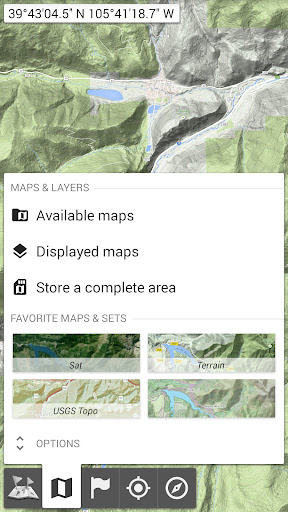
Bored to wait for maps to display? Use All-In-One OfflineMaps! Once displayed, maps are stored and remain available, quickly, even with no network access.
• Want more than just roads on your maps? You will find what you need here;
• Used to go to places with poor network coverage? Everything will stay available;
• Used to go abroad? You won’t be lost anymore;
• Have a data allowance limit? It will reduce your usage.
★★ Maps ★★
A lot of maps are available, including classical road maps, topographic maps, aerial (satellite) maps and various layers that can be added over any maps: OpenStreetMap (Roads, Topo), USGS National Map (Hi-res topo, Aerial imagery), Worldwide Military Soviet topo maps, etc.
• All maps can be stacked in layers, with precise opacity control;
• Select and store large areas in few clicks;
• Stored space is clear and can be easily deleted.
★★ Display, store and retrieve unlimited placemarks ★★
You can add various items on the map such as waypoints, icons, routes, areas and tracks.
You can easily manage them using the powerful SD-Card Placemarks Explorer.
★★ On-map GPS Location & Orientation ★★
Your real location and direction are clearly displayed on the map, which can be rotated to match your real orientation (depends on device capabilities).
Easy turn on/off to save battery.
And also:
• Metric, imperial and hybrid distance units;
• GPS Latitude/Longitude and grid coordinate formats (UTM, MGRS, USNG, OSGB Grid, Irish Grid, Swiss Grid, Lambert Grids, DFCI Grid, QTH Maidenhead Locator System, …);
• Ability to import hundreds of coordinate formats from https://www.spatialreference.org;
• On-map grids display;
• Full screen map view;
• Multi-touch zoom;
• …
★★ Need more? ★★
If you are a real adventurer, try AlpineQuest Off-Road Explorer, the complete outdoor solution based on All-In-One OfflineMaps, loaded with a powerful GPS Track Recorder and more: https://www.alpinequest.net/google-play
Opiniones de usuarios

no refleja las coordenadas reales si se hace una comparación un punto en Google earth con la aplicación refleja coordenadas distintas para un lugar específico

excelente aplicación,buena fuente de mapas,y opciones y configuraciones muy buenas,me ha funcionado para todos mis trabajos.

Es muy completa la app pero seria mejor si fuera posible generar archivos kml a partir de la grabacion de rutas (a la cual hay que mejorarle muchas cosas, wikiloc en ese sentido es mas simple de usar, pero muy mala para navegar). Superconfigurable y con muchas posbilidades de armar tu propio mapa a partir de la superposición de capas multiples que se descargan de diferentes plataformas de mapas y capas base como Open Street Maps y Bing (Google no). Solo hay agregarle seguimiento de rutas gpx!

es una muy buena aplicación y se ajusta a la forma de trabajo que desees de acuerdo a las opciones de la misma. se lo recomiendo
Cómo descargar All-In-One Offline Maps APK
- Ingrese el nombre del paquete
net.psyberia.offlinemapsen la APK Downloader. - Seleccione la arquitectura de su dispositivo (se recomienda ARM64 para dispositivos modernos).
- Haga clic en Descargar para obtener el archivo APK fusionado.
- Transfiera e instale el APK en su dispositivo Android.
- Manténgase actualizado: Visite APKDER.COM regularmente para buscar y descargar las últimas versiones seguras de sus aplicaciones favoritas.
Seguridad y Verificación de Firma
Esta descarga de APK es 100% segura. Verificamos que la firma criptográfica del archivo coincida con las credenciales oficiales del desarrollador. No se inyectan modificaciones ni adware.


